

Last updated: 15 July 2026
Important 2026 update: The Kinnaur Kailash Yatra is currently postponed until further orders. The Kinnaur district administration reported active glaciers, unstable boulders, rockfall, landslides and blocked sections between Gufa and Sorang. Pilgrims have been specifically advised not to attempt the route until an official reopening notice is issued. Check the District Kinnaur official notice before making any booking or travelling to the base.
The Kinnaur Kailash trek is a steep high-altitude pilgrimage in Himachal Pradesh. It leads to a natural rock pillar worshipped as a Shivling in the Kinner Kailash mountain range. Although the trekking distance may appear manageable, the rapid altitude gain, boulder fields, glaciers and unpredictable weather make it one of the most demanding pilgrimage routes in India.
Kinnaur Kailash Trek at a Glance
| Trek detail | Practical information |
|---|---|
| Location | Kinnaur district, Himachal Pradesh |
| Common base | Reckong Peo or Kalpa |
| Traditional trailhead | Tangling village |
| Trek destination | Natural Kinnaur Kailash Shivling |
| Shivling altitude | Approximately 4,800 metres |
| Kinnaur Kailash peak | Approximately 6,050 metres |
| Estimated distance | Around 30–40 km return, depending on the approved route |
| Difficulty | Difficult to very difficult |
| Normal trek duration | 2–3 trekking days, excluding travel and acclimatisation |
| Recommended trip duration | 5–6 days from Reckong Peo or Kalpa |
| Current 2026 status | Postponed until further orders |
Distances and campsite names can vary between route descriptions. Always follow the route, reporting point and overnight halts approved by the administration for that particular season.
What Is the Kinnaur Kailash Trek?
Kinnaur Kailash, also written as Kinner Kailash, is a sacred mountain in the Kinnaur region. The pilgrimage is associated with Lord Shiva and holds deep religious importance for local communities and visiting devotees.
The main destination of the yatra is a tall natural rock formation resembling a Shivling. It is commonly described as being about 79 feet high and is situated at approximately 4,800 metres. On clear days, changing sunlight can make the rock appear different in colour at different times.
A common mistake is to describe the yatra as a trek to the 6,050-metre summit of Kinnaur Kailash. The pilgrimage trail normally reaches the Shivling below the mountain summit. Climbing the actual peak is a technical mountaineering objective and should not be confused with the yatra.
The Kinnaur Kailash Parikrama is also a different journey. It follows a longer high-altitude circuit through the Charang La area and requires separate planning, permissions, equipment and experience.
Is the Kinnaur Kailash Trek Open in 2026?
No. As of 15 July 2026, the official yatra remains postponed.
The pilgrimage was initially proposed for 1 July to 30 July 2026, with mandatory registration and a limit of 375 pilgrims per day. However, those plans were superseded by the district administration’s notice dated 28 June 2026.
A reconnaissance team identified several serious hazards:
- Active glaciers covering parts of the trail
- Large and unstable boulders resting near melting glaciers
- Continuous danger of falling rocks and debris
- A blocked section between Gufa and Sorang
- Dangerous terrain between Miling Khata and the Holy Cave
- Increased landslide risk caused by melting snow and rising temperatures
This is not a routine weather delay. The administration has asked people not to undertake the pilgrimage until the route is inspected again and officially declared safe.
A tour operator, guide or social-media post cannot override an administrative closure. Do not enter the route through an alternative village to bypass restrictions.
Understanding the Traditional Kinnaur Kailash Trek Route
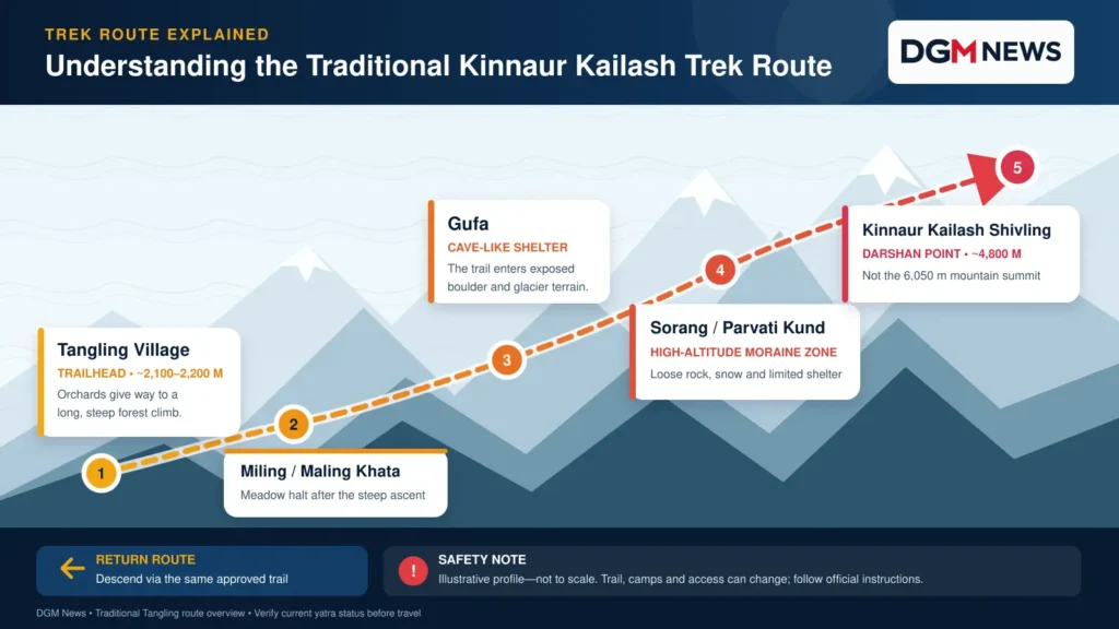
When officially open, the most frequently used route begins near Tangling village, across the Sutlej valley from the Reckong Peo and Kalpa side.
The traditional route is generally described in this order:
Tangling village → Miling or Maling Khata → Gufa → Sorang or Parvati Kund → Kinnaur Kailash Shivling
Spellings of Miling Khata and Maling Khata vary between local and published accounts. Ganesh Park, Ashiqui Park and the forest rest area may also appear as campsite or halt names in different itineraries.
Tangling to the Approved First Camp
The trek begins among village paths and orchards but soon becomes extremely steep. Trekkers gain considerable elevation over a relatively short horizontal distance. The climb passes through forest before reaching open meadows and basic camping areas.
This section can take most of the day. Water availability is not consistent, so trekkers must refill only at confirmed safe sources and carry sufficient water between them.
First Camp to Gufa and Sorang
Above the meadow camps, the terrain changes from forest and soil to exposed rock, moraine and boulder fields. Gufa refers to a cave-like shelter beneath large rocks. Sorang is associated with the Parvati Kund area in several local route descriptions.
Trail markings can become difficult to follow in fog, snow or darkness. This section should not be attempted without the officially approved route and experienced local support.
Sorang to the Shivling
The final approach is the hardest part. It involves loose rocks, steep gradients and exposure to rapidly changing high-altitude weather. Snow or ice may remain even when lower Kinnaur feels warm.
After darshan, pilgrims must descend through the same demanding terrain. Reaching the Shivling is only half the journey; fatigue-related slips frequently occur during descent.
A Safer Itinerary After the Route Reopens
The following is a planning framework, not permission to enter a closed trail. Official instructions must take priority.
Day 1: Reach Reckong Peo or Kalpa
Complete the long road journey and rest. Do not begin trekking immediately after an overnight bus or continuous drive.
Day 2: Acclimatise in Kalpa
Spend a full day at moderate altitude. Take a short walk, hydrate properly and check equipment. Use this day to confirm the latest route status, registration and weather warning.
Day 3: Report at the Official Base and Trek to Camp
Complete registration and medical formalities before travelling to the designated trailhead. Trek only to the campsite authorized for your batch.
Day 4: Shivling Darshan and Return to Camp
Start at the time directed by officials and guides. Turn back if the weather changes, the route becomes unstable or any group member develops altitude-related symptoms.
Day 5: Descend to Tangling
Descend carefully and report your return at the required checkpoint. Keep an additional buffer day for road closures or administrative delays.
How Difficult Is the Kinnaur Kailash Trek?
The Kinnaur Kailash trek should be treated as difficult to very difficult, not as a beginner-friendly religious walk.
Tangling is situated at roughly 2,100–2,200 metres, while the Shivling is close to 4,800 metres. Therefore, trekkers face an elevation gain of more than 2,500 metres. The main challenges include:
- Long and unusually steep climbs
- Rapid altitude gain
- Loose boulders and moraine
- Snow and glacier crossings in some conditions
- Limited shelter and water
- Cold nights and strong wind
- A demanding descent on tired legs
- Weak or unavailable mobile connectivity
Previous trekking experience above 3,500 metres is strongly recommended. Faith and determination are valuable, but neither replaces acclimatisation, physical fitness or safe route conditions.
How to Prepare Physically
Begin training at least six to eight weeks before departure. Your preparation should include brisk walking, stair climbing, cycling or jogging four to five days per week.
Add two weekly strength sessions covering squats, lunges, step-ups, calf raises and core exercises. Gradually practise walking uphill with the backpack you intend to carry.
Before considering the yatra, you should be comfortable walking for six to eight hours on uneven ground on consecutive days. A medical fitness certificate should be based on a genuine examination, not treated as paperwork.
People with heart, lung or uncontrolled blood-pressure conditions should seek individual medical advice before planning a high-altitude pilgrimage.
Best Time for the Kinnaur Kailash Trek
There is no permanently safe month for this route. The correct time is the period officially announced by the Kinnaur administration after inspecting the trail.
The organized yatra commonly falls around July or August. However, this overlaps with the monsoon, when landslides, washed-out crossings, falling rocks and poor visibility can interrupt the pilgrimage.
Never assume that clear weather in Kalpa means the upper trail is safe. Conditions near the Shivling can be completely different. Check both the District Kinnaur portal and the IMD Meteorological Centre Shimla before departure.
How to Reach the Trek Base
Most travellers reach Kinnaur by road.
The usual approach follows Chandigarh or Shimla to Narkanda, Rampur, Powari and Reckong Peo on NH-5. Buses and shared or private taxis operate towards Reckong Peo, but landslides and road maintenance can increase travel time considerably.
Kalpa and Reckong Peo are suitable bases for accommodation, supplies and acclimatisation. Access from the main road to Tangling or another designated trailhead must be arranged according to that year’s official yatra plan.
Avoid building a tight return schedule around a mountain pilgrimage. Keep at least one extra day for weather or road disruption.
Registration, Guide and Documents
When the yatra reopens, registration requirements may include a government photo ID, medical fitness certificate and reporting at the designated base camp. Daily limits, age rules, fees and registration channels can change each year.
Use a registered local guide even if solo travel is permitted. A reliable guide should know water sources, approved camps, escape points and current trail conditions.
Carry printed and digital copies of:
- Government-issued photo identification
- Registration confirmation
- Medical fitness certificate
- Emergency contact details
- Travel insurance information, if applicable
- Operator and guide contact information
Essential Packing List
Carry equipment suited to cold, wet and rocky conditions:
- Waterproof trekking shoes with tested grip
- Backpack with a rain cover
- Waterproof jacket and trousers
- Fleece and insulated outer jacket
- Thermal layer, gloves and warm cap
- UV-protection sunglasses and sunscreen
- Headlamp with spare batteries
- Trekking poles
- Two water bottles and a purification method
- High-energy snacks and oral rehydration salts
- Personal medicines and a compact first-aid kit
- Power bank, whistle and emergency blanket
- Dry bags for documents and clothes
- Reusable waste bag
Do not carry a heavy collection of unnecessary clothing. At the same time, never remove essential rain protection or insulation merely to reduce weight.
Altitude Sickness Must Be Taken Seriously
Acute mountain sickness can affect fit and experienced trekkers. Early symptoms include headache, nausea, dizziness, unusual tiredness, poor appetite and difficulty sleeping.
Do not climb higher when symptoms appear. If they become worse at the same altitude, descent is necessary. Confusion, inability to walk steadily, severe breathlessness at rest or a wet cough require urgent evacuation. The CDC’s high-altitude guidance also warns against continuing an ascent with worsening symptoms.
Medication such as acetazolamide should be taken only after discussing suitability and dosage with a qualified doctor.
Food, Camps and Trek Cost
Permanent facilities are limited above Tangling. Temporary camps, food stalls and medical support may operate during an organized yatra, but they should not be assumed available outside the official period.
A fixed cost cannot be quoted while the 2026 yatra is postponed. Future expenses will depend on transport, accommodation, guide charges, porter support, camping equipment and registration fees.
Before paying an operator, ask for written details covering route closure, refunds, evacuation, guide registration, equipment and excluded expenses.
Respect the Sacred Landscape
Kinnaur Kailash is a place of worship as well as a fragile Himalayan environment. Follow local customs, avoid loud music and do not photograph ceremonies or residents without consent.
Carry every piece of plastic, tissue and food packaging back to the base. Do not leave clothes, religious items or offerings on rocks. A responsible pilgrimage should not create work or danger for local residents and rescue teams.
Frequently Asked Questions
No. As of 15 July 2026, it is postponed until further orders. Wait for an official reopening announcement.
Published estimates range from approximately 30 to 40 km for the return journey. The actual distance depends on the trailhead, approved route and campsite.
It is not recommended as a first trek. The route involves rapid altitude gain, steep climbing and unstable rocky terrain.
Solo travel is unsafe on this route. Join an authorized batch and use a registered local guide after the yatra officially reopens.
No. Both names generally refer to the same sacred mountain and pilgrimage in Kinnaur.
The trekking portion may take two to three days. A safer plan requires five to six days from Kalpa or Reckong Peo, including acclimatisation and a weather buffer.
No. The pilgrimage normally leads to the sacred Shivling at approximately 4,800 metres. The mountain summit is a separate technical mountaineering objective.